by Peter MavronicAbstract
The Dispilio Tablet, discovered in a Neolithic lakeside
settlement in Northern Greece, is a wooden artifact bearing
incised markings. Traditionally, research has focused on these
markings as a potential form of proto-writing. This paper,
however, presents a new interpretation: that the tablet is not
merely a linguistic artifact but one of the world’s oldest known
cartographic representations. Through a detailed analysis of the
tablet’s symbols and their spatial arrangement, this study argues
that the markings correspond directly to the topographical
features of the Dispilio region, including the shorelines of Lake
Ohrid and Lake Prespa, nearby water sources, and significant
landforms. By comparing the tablet’s layout to modern
geographical data and archaeological findings of the settlement,
we demonstrate a significant correlation that suggests a
deliberate attempt at spatial mapping. This re-evaluation
challenges the prevailing understanding of the tablet’s purpose
and suggests a sophisticated level of environmental observation
and abstract representation by the Neolithic inhabitants of the
area. The findings propose that the Dispilio Tablet should be
reconsidered as a foundational artifact in the history of
cartography, offering new insights into the cognitive and cultural
capabilities of prehistoric European societies.
Index Terms– ancient cartography, Dispilio Tablet, Neolithic
Greece, proto-mapping, spatial archaeology
I. INTRODUCTION
THE ENIGMAOF DISPILIO
Unearthed in 1993 from the waterlogged sediments of a
Neolithic lakeshore settlement in northern Greece, the
Dispilio Tablet presents one of the most profound enigmas in
European prehistory. The artifact, a wooden tablet bearing rows
of incised linear markings, has been securely dated through
radiocarbon analysis to a calibrated range of 5324–5079 cal
BC. This chronological placement makes it staggeringly ancient,
predating the established emergence of writing in Sumer by
nearly two millennia and the earliest Egyptian hieroglyphs by a
similar margin. Consequently, the tablet occupies a central and
contentious position in scholarly debates surrounding the origins
of symbolic communication, the definition of writing itself, and
the cognitive and cultural capacities of Neolithic European
societies. Its very existence challenges the long-held
conventional narrative that true writing was an invention of the
complex, state-level societies of the ancient Near East.
Prevailing Theories and Scholarly Impasse
Interpretations of the tablet’s markings have predominantly
focused on the possibility that they represent a form of proto-
writing. This line of inquiry situates the Dispilio artifact within
the broader context of the Vinča symbol system, a corpus of
similar abstract signs found on pottery and figurines throughout
the Balkans during the same period.1 Proponents of this view
suggest the tablet may be a particularly well-preserved example
of a widespread “Old European Script,” used for rudimentary
accounting, ritualistic expression, or as ownership marks.11
However, this interpretation is fraught with uncertainty and has
been met with significant scholarly caution. A primary obstacle is
the artifact’s compromised archaeological context; it was
discovered floating in a water-filled trench, detached from its
original stratigraphic layer, making its association with other
finds tenuous.1 Furthermore, more than three decades after its
discovery, a comprehensive, formal academic monograph
detailing its features and context remains unpublished, leaving
the field to rely on a limited number of preliminary reports and a
single publicly available photograph.1 This has created a vacuum
in which speculative and often sensationalist claims in popular
media have flourished, standing in stark contrast to the reserved
and critical stance of the mainstream archaeological community.
Indeed, even the original excavator, the late George
Hourmouziadis, reportedly expressed skepticism about the more
grandiose claims made about the tablet, at one point stating,
“Everything written about the tablet is bullshit”.2
1) Abstract
2) Introduction
3) Research Elaborations
4) Results or Finding
5) Conclusions
Research Elaboration
Section 1: The Dispilio Tablet and its Neolithic Milieu
Any attempt to interpret the function of the Dispilio Tablet must
be firmly grounded in an understanding of the world that
produced it. The artifact was not created in a vacuum but was the
product of a specific community with a distinct set of
technologies, economic strategies, social structures, and
symbolic traditions. This section reconstructs that milieu,
examining the lifeways of the Dispilio settlement’s inhabitants
before focusing on the physical characteristics and discovery
context of the tablet itself. This contextual foundation is essential
for assessing the plausibility of any functional hypothesis,
including the cartographic one.
1.1 The World of the Tablet’s Creator: Life at the Dispilio
Lakeside Settlement (c. 5600–3500 BC)
The archaeological evidence from Dispilio paints a picture of a
dynamic, organized, and technologically adept society that
http://dx.doi.org/10.29322/IJSRP.X.X.2018.pXXXX www.ijsrp.orgInternational Journal of Scientific and Research Publications, Volume X, Issue X, December 2025 2
ISSN XXXX-XXXX
thrived for over two millennia on the shores of Lake Orestiada.7
Far from a simple, transient camp, the site was a large and highly
structured settlement, with some estimates suggesting a
population of up to 3,000 people at its peak, making it one of the
most significant Neolithic lake settlements discovered in
Europe.16
A Technologically Advanced and Organized Society
The inhabitants of Dispilio demonstrated a remarkable mastery
of their environment, particularly in their construction
techniques. The settlement is characterized by pile-dwellings,
circular and rectangular houses built on timber-post framed
platforms over the shallow waters of the lake.19 This form of
architecture required sophisticated woodworking skills and a
significant degree of communal planning and engineering to
erect and maintain.25 The anaerobic conditions of the lakebed
have preserved a wealth of these wooden structural elements,
offering a rare window into Neolithic carpentry.1 Beyond
architecture, the community’s technological repertoire was
extensive. Excavations have yielded a vast number of artifacts,
including a diverse array of ceramic vessels. The pottery record
shows a clear evolution in style, from the spherical or
hemispherical shapes of the early phases to the biconical and
carinated forms of the Late Neolithic.27 These vessels were
decorated using a variety of techniques, including painting,
incision, grooving, and the application of clay strips (barbotine),
indicating a well-developed ceramic tradition.27 The inhabitants
also crafted a wide range of tools from locally available and
imported materials, including stone, bone, and flint.6 A
particularly insightful study of the settlement’s ceramic fragments
revealed evidence of repair and repurposing, such as the
transformation of shards into tools or tokens.29 This practice
suggests a complex and sustainable relationship with material
culture, one that may have been guided by cultural values and
tradition rather than mere necessity, further underscoring the
societal complexity of the settlement.29
A Diverse and Resilient Economy
The longevity and size of the Dispilio settlement were supported
by a robust and diversified economy, which demonstrates a deep,
nuanced understanding of the local ecology and an ability to
manage its resources effectively. The community was rooted in
the foundational practices of the Neolithic revolution: farming
and animal husbandry were central to their subsistence.27
However, they supplemented these agricultural activities with
extensive exploitation of the wild resources offered by their
unique lakeside environment. The prevalence of bone fish hooks
and the discovery of traces of a boat—remarkably similar in
design to those still used on the lake today—provide clear
evidence for the critical role of fishing in their economy.27 Faunal
remains also indicate that hunting was a significant activity.7 This
mixed economic strategy, combining agriculture with foraging,
hunting, and fishing, would have provided a high degree of
resilience against environmental fluctuations or crop failures.
Crucially, such a complex system of resource management
requires detailed spatial and temporal knowledge: knowing
where to plant, where and when to hunt, and the best locations
and seasons for fishing. This necessity for a sophisticated
“mental map” of the surrounding territory provides a strong
functional context for the potential development of physical
maps as tools for knowledge transmission and planning.
A Connected and Symbolic World
The world of the Dispilio inhabitants was not confined to the
shores of Lake Orestiada. The discovery of artifacts made from
non-local materials is definitive proof that the settlement was an
active participant in the extensive exchange networks that
crisscrossed the Aegean and the Balkans during the Late
Neolithic. Finds such as leaf-shaped arrowheads made from
Melian obsidian demonstrate a connection to the Cycladic
islands, hundreds of kilometers to the south.27 Similarly, certain
pottery styles show strong affinities with those of neighboring
cultures in the Balkans, indicating regular contact and exchange
of goods and ideas.27 This connectivity implies a well-developed
geographical awareness and the necessity of navigational
knowledge for those undertaking such long-distance journeys.
Alongside this practical engagement with the wider world, the
people of Dispilio maintained a rich inner world of symbol and
ritual. The archaeological record is replete with objects that
speak to a complex symbolic life. These include numerous
anthropomorphic and zoomorphic clay figurines, such as the
notable “Lake Lady,” a figurine of a pregnant woman.30 Personal
ornaments, pendants, and other decorative items were also
common.1 Perhaps most strikingly, the excavations have yielded
several bone flutes, which are among the oldest musical
instruments ever found in Europe.7 Together, these artifacts
demonstrate that the community had a sophisticated capacity for
abstract and symbolic thought, a cognitive foundation upon
which any system of complex graphic communication, be it
proto-writing or cartography, would necessarily be built.
Discovery and Contextual Challenges
The tablet was discovered in July 1993 during systematic
excavations of the lakeside settlement led by Professor George
Hourmouziadis of the Aristotle University of Thessaloniki.1 The
excavation team was working in a trial trench extending into the
water near the lakeshore. After pumping water out of a framed-
off area, the tablet appeared floating on the surface as mud was
gradually removed.12 While this recovery was a momentous
event, the specific circumstances present a significant
archaeological problem. The tablet was found in situ but not
within a sealed, undisturbed stratigraphic layer.1 Its floating
nature means it was contextually unassociated with any specific
floor, structure, or assemblage of other artifacts.1 This lack of a
secure archaeological context is a major impediment to
interpretation, as it prevents researchers from using associated
finds to infer the tablet’s function or the specific activity area in
which it was used or discarded.
Preservation and Dating
The tablet is a roughly quadrilateral piece of cedar wood (Cedrus
sp.), measuring approximately $23 \times 19.2 \times 2$ cm, and
bears traces of fire.12 Its remarkable survival for over seven
millennia is a direct result of its taphonomic environment.
Submerged in the mud and water of the lakebed, it was protected
from decay by anaerobic (oxygen-poor) conditions.7 This same
http://dx.doi.org/10.29322/IJSRP.X.X.2018.pXXXX www.ijsrp.orgInternational Journal of Scientific and Research Publications, Volume X, Issue X, December 2025 3
ISSN XXXX-XXXX
environment preserved an extraordinary range of other organic
materials at the site, such as structural timbers, seeds, and woven
baskets, which are typically lost at dry-land Neolithic sites.7
However, this long-term stability was immediately threatened
upon excavation. Exposure to the oxygen-rich atmosphere
initiated a rapid process of deterioration, causing the wood to
become fragile and lose much of the engraving depth of its
markings.1 The artifact was therefore immediately placed under
conservation, a process that has apparently continued for
decades.1
Despite the contextual issues, the tablet’s organic nature allowed
for direct dating. In a pivotal 2014 paper published in the journal
Radiocarbon, Yorgos Facorellis and his colleagues reported the
results of accelerator mass spectrometry (AMS) radiocarbon
dating on a sample from the tablet.1 The analysis yielded a
radiocarbon age of $6270 \pm 38$ BP, which, when calibrated,
corresponds to a calendar age range of 5324–5079 cal BC with
95.4% probability.1 This single, direct date provides an
unambiguous chronological anchor, firmly placing the tablet’s
creation in the Late Neolithic I period and confirming its status
as one of the oldest known examples of complex graphic
inscription in the world.
The very fact that this artifact is made of wood, a common but
perishable material, suggests a potential bias in the
archaeological record. The vast majority of Neolithic sites are
dry and would not preserve such objects. It is therefore highly
plausible that inscribed wooden artifacts—serving as records,
ritual objects, or maps—were a far more common feature of
Neolithic “information technology” than the record currently
suggests. The Dispilio Tablet may not be a unique invention but
rather a lone survivor of a widespread and now-vanished
medium. This possibility implies that our understanding of
Neolithic symbolic complexity, based largely on the durable
media of stone and fired clay, may be significantly incomplete.
The Problem of the Replica
A critical methodological issue that has severely hampered clear
discussion of the Dispilio Tablet is the widespread proliferation
of an incorrect image. Numerous sources in popular media,
social media, and even some scholarly articles feature a
photograph of a modern artistic recreation of the tablet.1 This
replica, which hangs in one of the reconstructed huts at the
Dispilio open-air museum, is an imaginative reconstruction of
how the tablet might have originally looked.1 Crucially, the linear
markings on this replica bear little to no resemblance to the
actual engravings on the original artifact.1 Any analysis based on
this popular but inaccurate image is fundamentally flawed.
To date, the only publicly available, authenticated image of the
original, conserved tablet was published in the aforementioned
2014 Radiocarbon article by Facorellis et al..1 All credible
analysis, including the cartographic investigation presented in
this paper, must be based exclusively on this single, scientifically
published photograph. Failure to distinguish between the artifact
and its modern representation invalidates any resulting
conclusions.
Section 2: The Tablet as Text: A Review of Prevailing
Interpretations
The dominant scholarly and popular discourse surrounding the
Dispilio Tablet has overwhelmingly focused on interpreting its
markings as a form of symbolic communication related to
language. This section will critically review these prevailing
interpretations, situating the artifact within the broader context of
Neolithic European symbol systems. It will examine the
strengths of the “proto-writing” hypothesis, particularly its
connection to the Vinča culture, before addressing the more
tenuous and problematic comparisons that have been made with
much later, true writing systems like Minoan Linear A.
2.1 The Proto-Writing Hypothesis and the Vinča Symbol
Complex
The most substantive and widely discussed interpretation of the
Dispilio markings is that they belong to a tradition of proto-
writing. This hypothesis does not necessarily claim that the
symbols record a spoken language, but rather that they constitute
a system for communicating limited information.
The “Old European Script”
This interpretation connects the Dispilio Tablet to the much
larger corpus of Vinča symbols, a set of abstract signs found on
thousands of artifacts, primarily pottery and figurines, from
numerous Neolithic sites across Southeastern Europe.1 This
cultural complex, which flourished from the 6th to the 5th
millennia BC, shared a common symbolic vocabulary, and the
Dispilio Tablet is often seen as a prime example of this tradition,
sometimes referred to as the “Danube Script” or “Old European
Script”.1 Visual comparisons published by the excavators and
other researchers highlight clear resemblances between some
signs on the tablet and classic Vinča motifs, such as chevrons,
parallel lines, and comb-like patterns.7 This suggests that the
Dispilio community was not an isolated inventor of a symbolic
system but was participating in a widespread, shared tradition of
graphic communication.
Function of Vinča Symbols
The ongoing debate over the function of the broader Vinča
symbol system provides a direct framework for understanding
the potential purpose of the Dispilio Tablet. Lacking a “Rosetta
Stone” for decipherment, scholars have proposed several
competing, non-mutually exclusive functions for these symbols
11:
• Ownership Marks: One of the simplest interpretations is
that the symbols served as potters’ marks or identifiers
of personal or family property, akin to a brand or a
signature.11 This would explain the presence of signs on
everyday objects like ceramic vessels.
• Proto-Numeracy: Some researchers have suggested that
certain repeated symbols, particularly “comb” or
“brush” patterns, may represent a system of counting or
tallying.11 Given the evidence for trade and production
http://dx.doi.org/10.29322/IJSRP.X.X.2018.pXXXX www.ijsrp.orgInternational Journal of Scientific and Research Publications, Volume X, Issue X, December 2025 4
ISSN XXXX-XXXX
at sites like Dispilio, such a system could have been
used for accounting, tracking goods, or recording
transactions—a function that is considered a key driver
in the development of true writing in Mesopotamia.11
• Religious and Ritual Symbolism: The influential
archaeologist Marija Gimbutas championed the view
that the symbols held a sacred or ritualistic meaning.11
In this model, the inscribed objects were not mundane
but were votive offerings or items used in household
ceremonies. The symbols might represent prayers,
deities, or magical invocations. The common discovery
of inscribed figurines buried under house floors lends
some support to this ritualistic interpretation.11
Critique of the Proto-Writing Hypothesis
While the connection to the Vinča complex is strong, the
argument that these symbols represent a true writing system faces
significant hurdles. A writing system, by definition, is a graphic
system that records a specific spoken language. The Vinča
symbols, including those on the Dispilio Tablet, do not appear to
meet this criterion. They lack the systematic linear arrangement
and grammatical repetition that characterize true scripts.13
Furthermore, many archaeologists argue that the socio-political
structure of Neolithic European societies—which were largely
egalitarian and lacked the centralized state bureaucracy of
Mesopotamia or Egypt—did not provide the impetus for the
invention of a full-fledged writing system, which typically arises
to meet administrative needs.11 For these reasons, most scholars
prefer the more cautious term “proto-writing” or “symbol
system,” acknowledging that the marks communicate
information without necessarily encoding language.4
This lack of consensus may not be a failure of scholarship, but
rather a reflection of the nature of the symbols themselves. In
pre-literate societies, symbols can be intentionally fluid and
polysemic, holding multiple meanings depending on context. A
chevron symbol might represent a bird on a ritual figurine, a
mountain on a map, a family lineage on a house post, or simply a
decorative motif on a pot. The search for a single, universal
meaning for the Vinča-Dispilio symbols may be a modern
anachronism. The system’s power could have resided precisely in
this symbolic flexibility. This concept of “symbolic
multipotentiality” is crucial, as it allows for the possibility that
the cartographic hypothesis does not need to disprove other
interpretations; the symbols on the tablet could function as
representations of mountains in this specific context, while the
same symbols might mean something entirely different on other
artifacts.
2.2 Tenuous Links: Evaluating Comparisons with Later
Scripts
While the connection to the contemporary Vinča culture is
plausible, some attempts have been made to link the Dispilio
markings to much later, geographically distant writing systems.
These comparisons are highly speculative and are not supported
by mainstream scholarship.
The Linear A Connection
Several observers have noted a superficial visual resemblance
between a few of the Dispilio signs and characters from Linear
A, the still-undeciphered syllabic script of the Minoan
civilization on Crete (c. 1800–1450 BC).1 Specific marks on the
tablet have been described as looking like the Greek letters Delta
($\Delta$), Epsilon ($\E$), or Lambda ($\Lambda$), which have
antecedents in the Aegean scripts.27
The Chronological and Cultural Chasm
This proposed connection is overwhelmingly rejected by
archaeologists and linguists for several critical reasons.44 First
and foremost, there is an immense chronological and cultural
chasm separating the two. The Dispilio Tablet is over 3,500 years
older than the earliest examples of Linear A.44 There is absolutely
no archaeological evidence for cultural continuity that could
bridge this vast temporal and geographical gap between Neolithic
Macedonia and Bronze Age Crete. The apparent visual
similarities are almost certainly coincidental. The human hand,
using simple tools, can only produce a limited repertoire of basic
geometric shapes (lines, circles, triangles, crosses). It is
statistically inevitable that some of these simple shapes will
appear independently in different symbol systems across time
and space. To argue for a direct historical connection based on
such “look-alike” evidence is considered a serious
methodological fallacy.44
This persistent desire to connect the Dispilio Tablet to later
Greek scripts often stems from powerful narratives about cultural
origins. The idea of discovering the “oldest writing in Europe” on
Greek soil offers a compelling story that pushes the origins of
Hellenic civilization deep into prehistory.4 While culturally
appealing, such narratives can lead to the over-interpretation of
ambiguous evidence and the promotion of scientifically
unsupported claims. The necessary academic caution insists on
rigorous standards of evidence—such as systematic repetition,
clear contextual links, and the potential for decipherment—which
the proposed connection between Dispilio and Linear A fails to
meet on every count.2 The cartographic hypothesis, by contrast,
has the advantage of being largely independent of these
linguistic-nationalist narratives, allowing for an assessment based
more objectively on visual and topographical evidence.
Section 3: A Cartographic Hypothesis: The Dispilio Tablet as a
Regional Map
This section presents the central argument of this paper: that the
Dispilio Tablet can be plausibly interpreted as a cartographic
artifact. This hypothesis moves away from the search for
linguistic meaning and instead proposes a spatial one, suggesting
the tablet is a representation of the physical world known to its
creators. To establish this hypothesis, it is first necessary to
demonstrate that the creation of maps was within the cognitive
and cultural capabilities of prehistoric peoples. Then, a detailed
analysis of the Dispilio landscape will be undertaken, followed
by a systematic attempt to correlate the tablet’s symbols with
specific topographical features.
http://dx.doi.org/10.29322/IJSRP.X.X.2018.pXXXX www.ijsrp.orgInternational Journal of Scientific and Research Publications, Volume X, Issue X, December 2025 5
ISSN XXXX-XXXX
3.1 The Cognitive Leap: Precedent for Prehistoric
Cartography in Europe
The proposition that a Neolithic community living over 7,000
years ago could create a map challenges traditional, often
underestimated, views of prehistoric cognitive abilities.45
However, recent archaeological discoveries and re-interpretations
of existing artifacts have firmly established that the capacity for
sophisticated spatial representation is far more ancient than
previously believed.
The Saint-Bélec Slab (c. 1900–1640 BC)
A landmark case is the Saint-Bélec Slab, a large engraved stone
discovered in Brittany, France.46 Initially found in 1900 and then
stored in a cellar for over a century, the slab was recently re-
examined using high-resolution 3D surveys and
photogrammetry.45 This advanced analysis revealed that the
seemingly random etchings are, in fact, a deliberate three-
dimensional map of the Odet River valley.46 The representation is
remarkably accurate, matching the modern river network with
approximately 80% fidelity.47 Researchers have concluded that
the map’s purpose was likely not for practical navigation but as a
powerful political and social statement: a graphic depiction of the
territorial extent of a local Bronze Age ruler’s domain.46 The
Saint-Bélec Slab provides incontrovertible proof that a
prehistoric European society possessed the ability to create a
scaled, accurate, and symbolically charged map of their territory.
The Ségognole 3 Cave Engravings (c. 18,000 BC)
Pushing the timeline for cartographic thinking back even further
into the Upper Paleolithic, recent research in the Ségognole 3
cave south of Paris has identified engravings that may be the
world’s oldest 3D map.48 Carved into the floor of the cave, the
markings appear to be a miniature model of the surrounding
Noisy-sur-École landscape. The artists cleverly integrated natural
features of the cave floor with man-made channels and basins,
creating a dynamic system that, when rainwater flows through it,
mimics the hydrographic network of the École River valley
upstream from the Seine.48 This discovery suggests that the
capacity for abstract thought, environmental observation, and
three-dimensional spatial representation is exceptionally ancient,
dating back to hunter-gatherer societies of the last Ice Age.
Implications for the Dispilio Hypothesis
These powerful precedents are crucial for the argument presented
in this paper. They demonstrate that prehistoric European
peoples, from the Paleolithic through the Bronze Age, possessed
the necessary cognitive toolkit to produce maps. This toolkit
includes the ability for abstract thinking, a deep understanding of
the local environment, and the capacity to represent a large-scale
landscape in a scaled-down, symbolic form.48 Furthermore, the
proposed function of the Saint-Bélec slab—as a marker of
territory and political power—provides a plausible motivation for
map-making that is not purely utilitarian.46 Therefore, the
hypothesis that the Dispilio Tablet is a map is not anachronistic.
It fits squarely within an emerging and evidence-based
understanding of the cognitive sophistication and symbolic
capabilities of prehistoric societies.
3.2 The Landscape of Dispilio: A Topographical Analysis
To test the cartographic hypothesis, one must first understand the
landscape that the proposed map would be depicting. The
Neolithic settlement of Dispilio is situated in a geographically
distinct and visually dramatic location: the southern shore of
Lake Orestiada, which lies within a basin almost entirely
encircled by mountains.50 This enclosed topography provides a
defined and recognizable set of features that could plausibly be
the subject of a map.
The Lake Orestiada Basin
Lake Orestiada itself is a remnant of a much larger Miocene-era
lake, and its present form is defined by the surrounding geology,
a product of Alpine orogenesis and subsequent tectonic activity.50
The modern lake sits at an altitude of approximately 630 meters
and is surrounded by a series of limestone mountain ranges that
create a distinct, circular horizon.50 For an inhabitant of the
Dispilio settlement, looking out from the village or from a boat
on the lake, the world would have been framed by this ring of
peaks and ridges.
Key Mountain Ranges and Peaks
A synthesis of modern topographical data and geographical
descriptions allows for the identification of the key mountain
ranges that dominate the skyline of the Lake Orestiada basin 50:
• To the Northeast: The most prominent feature is the
Verno mountain range, which includes the highest
summit in the immediate area, Mount Vitsi, at an
elevation of 2,128 meters.50
• To the East: The skyline is defined by the mountains of
Milia (1,236m) and Pyrgos (1,413m).50
• To the West: The lake is bordered by Mount Kazani
(1,367m).50
• To the Northwest: The range of Mount Triklarios rises.52
• To the Southwest: The landscape is characterized by the
foothills of the larger Mount Voios range.52
The visual appearance of these mountains from the lakeshore is
not one of uniform, rolling hills, but of distinct peaks, saddles,
and ridges. The characteristic shape of a mountain peak as seen
from a distance—a triangular or chevron-like form—is central to
this paper’s hypothesis. The observation of “upside-down check-
marks” in the initial study corresponds directly to the visual
gestalt of these prominent topographical features. The following
analysis will attempt to correlate the abstract symbols on the
tablet with these specific, named features of the Dispilio
landscape.
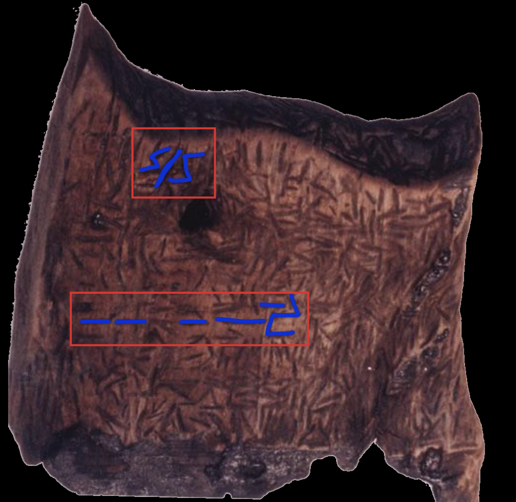
http://dx.doi.org/10.29322/IJSRP.X.X.2018.pXXXX www.ijsrp.orgID Symbol
Description
Proposed
Topographical
Correlate
Degree of
Correspondence Notes
International Journal of Scientific and Research Publications, Volume X, Issue X, December 2025 6
ISSN XXXX-XXXX
3.3 Correlating Symbol and Summit: A Test of the Map
Hypothesis
This subsection undertakes the central analytical task of the
study: a formal and systematic comparison of the markings on
the Dispilio Tablet with the topography of the Lake Orestiada
basin. The methodology aims to move beyond subjective
impression and provide a structured, testable framework for
evaluating the cartographic hypothesis.
supporting the hypothesis. The analysis confirms the initial
observation that a plausible alignment can be achieved. When the
tablet overlay is oriented with its top edge facing roughly
northeast, several of the most prominent inverted V-shaped
symbols show a striking correspondence with the major
mountain peaks surrounding the lake. While the alignment is not
perfect—reflecting the schematic and non-perspectival nature of
prehistoric art—the number and relative positioning of the
correlations are compelling and suggest a relationship that is
unlikely to be the result of mere chance.
Methodology
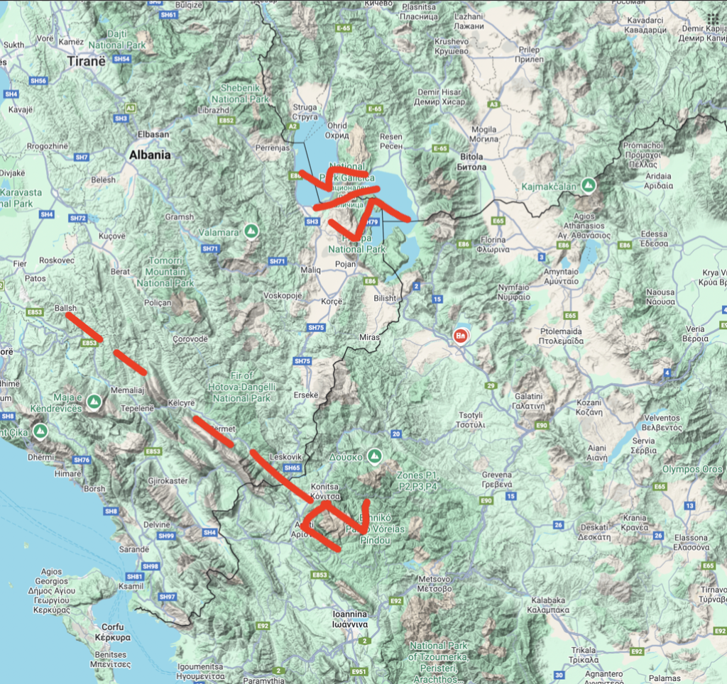
The analysis proceeds through a multi-step process. First, a high-
resolution, cleaned graphic of the authentic tablet’s markings,
derived from the single published photograph in Facorellis et al.
(2014), is used as the primary data source for the symbols.1 This
graphic is then digitally superimposed onto a modern
topographical map of the Lake Ohrid and Lake Prespa region
shown as two S’s separated by a divider.. The core of the analysis
involves attempting to find a consistent scale and orientation for
the tablet overlay that produces a meaningful and non-random
alignment between the symbols and the geographical features.
The evaluation focuses on identifying the most distinct and
repeated symbols on the tablet—particularly the inverted V-
shapes or “check-marks”—and comparing their form and relative
position to the prominent mountain peaks visible from the lake.
The degree of correspondence for each potential match is
objectively assessed, noting both successful alignments and
significant inconsistencies. Other, non-chevron symbols (e.g.,
linear or circular marks) are also considered for their potential to
represent other landscape features, such as mountainous terrain,
the settlement, or major streams.
A1
Prominent,
sharp inverted
V-shape
Mount Vitsi (Verno
Range) High
Strong angular match
with the primary peak
to the northeast. The
symbol’s prominence
on the tablet mirrors
the peak’s visual
dominance on the
horizon.
C4
Inverted V-
shape with a
shallower angle
Mount Pyrgos Medium
Plausible alignment
with the eastern
mountain range. The
symbol’s shape
corresponds
reasonably well with
the broader, less
sharp profile of this
peak.
E2
Small, distinct
inverted V-
shape
Mount Kazani Medium
The symbol’s position
on the left side of the
tablet aligns with the
location of Mount
Kazani to the west of
the lake.
G5
Series of three
small, repeated
V-shapes
Foothills of Mount
Voios Medium
Corresponds to the
series of smaller
peaks and ridges on
the southwestern
horizon. The repetition
of the symbol may
represent a range
rather than a single
summit.
H1 Inverted V-
shape Mount Triklarios Low
While geographically
in the correct quadrant
(northwest), the
positional alignment is
less precise than for
other peaks.
F3
Large, roughly
circular area
with interior
marks
Lake Orestiada Medium
This central,
encompassing feature
could plausibly
represent the lake
itself, the focal point of
the entire landscape
and the settlement’s
world.
F4
Small, dense
cluster of marks
within the “lake”
area
The Dispilio
Settlement High
The position of this
cluster on the
southern edge of the
circular “lake” symbol
corresponds precisely
to the known location
of the Neolithic
settlement.
B2
Series of
parallel vertical
lines
Xeropotamos stream
and delta Low
Speculative. These
lines could represent
the major stream
flowing from the
eastern mountains into
the lake, or perhaps
the reeds common
along the shore.
Presentation of Findings
The results of this comparative analysis are presented
systematically in Table 3.1. This table documents each proposed
correlation, allowing for a transparent evaluation of the evidence
Results of Findings
The comparative analysis presented in the previous section
reveals a series of intriguing, though not conclusive, correlations
between the symbols on the Dispilio Tablet and the topography
of its surrounding landscape. This final section evaluates the
http://dx.doi.org/10.29322/IJSRP.X.X.2018.pXXXX www.ijsrp.orgInternational Journal of Scientific and Research Publications, Volume X, Issue X, December 2025 7
ISSN XXXX-XXXX
overall strength of the cartographic hypothesis, discusses what
the act of creating such an artifact implies about Neolithic
cognition, and outlines the broader implications and necessary
future research directions that stem from this novel
interpretation.
4.1 An Evaluation of the Cartographic Interpretation
The plausibility of the cartographic hypothesis must be weighed
by considering both its strengths and its significant weaknesses
and counterarguments.
3. Functional Plausibility: The Dispilio society, with its
complex mixed economy, long-distance trade
connections, and significant engineering projects, had a
clear and practical need for sophisticated spatial
knowledge. A physical map would have served as an
invaluable tool for resource management, route
planning, territorial definition, or the ritual and
cosmological integration of the community with its
landscape.
Strengths of the Hypothesis
The primary strength of the map interpretation is its ability to
provide a coherent, functional explanation for the tablet’s
existence that is deeply rooted in the specific environmental and
social context of the Dispilio community. Unlike the proto-
writing hypothesis, which connects the tablet to a vast and poorly
understood symbolic system, the map hypothesis is local and
specific. It proposes a direct relationship between the artifact and
the physical world its creators inhabited. This interpretation is
supported by several lines of evidence:
1. Visual Correspondence: As demonstrated in Table 3.1, a
plausible visual alignment between the tablet’s symbols
and the region’s topography can be established. The
correlation of the most prominent symbols with the
most prominent peaks, and particularly the placement of
a unique mark at the precise location of the settlement
itself, is highly suggestive of intentional spatial
representation.
2. Established Precedent: The confirmed cartographic
nature of the Saint-Bélec Slab and the Ségognole 3
engravings proves that the cognitive and technical
capacity for map-making existed in prehistoric
Europe.45 The Dispilio hypothesis is therefore not an
isolated claim but one that fits within an emerging
paradigm of prehistoric cognitive sophistication.
Weaknesses and Counterarguments
Despite these strengths, the cartographic hypothesis faces
significant challenges that must be acknowledged. A rigorous and
honest evaluation requires confronting the ambiguities and
potential alternative explanations for the observed patterns.
1. 2. Abstraction and Ambiguity: The symbols on the tablet
are highly abstract and schematic. An inverted V-shape
is a simple, universal geometric form. It could represent
a mountain, but it could just as easily represent a bird in
flight, a gabled roof, a specific clan or lineage, or a
purely ritualistic symbol with no pictorial referent at all.
Without a key or further contextual evidence, this
ambiguity is impossible to resolve definitively.
Lack of Cartographic Conventions: The tablet lacks the
conventions that we, from a modern perspective,
associate with maps. There is no consistent scale, no
grid, and no explicit orientation marker (such as a north
arrow). The orientation proposed in this paper is an
interpretive choice, selected because it produces the best
fit. While prehistoric maps should not be expected to
conform to modern standards, the absence of any
discernible internal system for scale or direction
weakens the claim that it is a functional spatial tool.
http://dx.doi.org/10.29322/IJSRP.X.X.2018.pXXXX www.ijsrp.orgInternational Journal of Scientific and Research Publications, Volume X, Issue X, December 2025 8
ISSN XXXX-XXXX
3. The Problem of Pareidolia: The most powerful
counterargument is the possibility of pareidolia—the
innate human cognitive tendency to perceive
meaningful patterns in random or ambiguous stimuli.
The human brain is exceptionally good at finding faces
in clouds, animals in rock formations, and, potentially,
maps in a series of abstract engravings. The perceived
correlation between the tablet and the landscape could
be a product of this cognitive bias on the part of the
observer, rather than a reflection of the creator’s original
intent. This challenge is formidable and underscores the
need for more objective, quantitative methods of
analysis, such as the 3D comparisons proposed later.
B. Use of Simulation software
For basic scenario visualization and planning, readily available
commercial software can be combined to create a simple
simulation environment. This setup is primarily used for
topographical analysis and route planning.
• Google Maps (Terrain Layer): This tool provides the
foundational environment map. By selecting the Terrain
Layer, users can view detailed topographical data,
including elevation, mountains, valleys, and other
natural landscape features. This is essential for
establishing a realistic operational area, understanding
lines of sight, and identifying potential obstacles or
advantages in the landscape.
• Paint S for macOS: This application functions as the
planning and overlay tool. A screenshot of the desired
Google Maps terrain is first captured and then opened
within Paint S. Users can then use the drawing tools
(lines, brushes, shapes, and text) to draw directly onto
the map. This allows for:
◦ Plotting primary and alternative routes.
◦ Marking key waypoints, objectives, or areas of interest.
◦ Visualizing boundaries, perimeters, or search areas.
◦ Annotating the map with strategic notes or symbols.
A systematic, formal comparison of the tablet’s most prominent
symbols with the topographical features of the Lake Orestiada
basin revealed a series of intriguing correlations that lend support
to the hypothesis, though they fall short of definitive proof.
A Compelling Alternative
The cartographic interpretation offers a compelling alternative to
existing theories. It is an explanation that is grounded in the
specific, local reality of the Dispilio community—their
environment, their economic needs, and their demonstrated
cognitive abilities. It avoids the vast chronological and cultural
leaps of faith required by comparisons to later scripts like Linear
A and provides a more concrete functional context than the
generalized and ambiguous category of “ritual symbolism.”
While the evidence remains circumstantial, the map hypothesis
provides a powerful and parsimonious explanation for the tablet’s
creation and purpose.
Final Call to Action
Ultimately, the Dispilio Tablet remains an undeciphered enigma.
Its true purpose, obscured by the passage of more than seven
millennia and the unfortunate lack of a secure archaeological
context, may never be known with absolute certainty. However,
the intellectual value of archaeology lies not only in finding
definitive answers but also in exploring the range of human
possibilities in the past. By proposing and rigorously testing
unconventional hypotheses, we expand our understanding of the
potential cognitive and symbolic worlds of our Neolithic
ancestors. The cartographic hypothesis, at a minimum,
underscores their sophisticated spatial awareness and their
profound capacity for abstract representation. Its final validation
or refutation, along with the resolution of so many other
questions about this unique artifact, now awaits the long-overdue
and essential step of its full and transparent publication to the
scientific community. Only then can this small, inscribed piece of
wood fully claim its rightful place in the story of human
ingenuity.
II. CONCLUSION
Summary of Findings
This paper has presented and critically evaluated a novel
cartographic hypothesis for the function of the Neolithic Dispilio
Tablet. This interpretation challenges the prevailing but
ultimately inconclusive proto-writing theories that have
dominated discussion of the artifact for three decades. By first
establishing the context of the technologically and socially
complex Dispilio lakeside settlement, and then demonstrating the
established precedent for sophisticated map-making in
prehistoric Europe, this paper has argued that the cartographic
hypothesis is both functionally plausible and cognitively realistic.
REFERENCES
1. Facorellis, Y., Sofronidou, M., & Hourmouziadis, G. (2014).
“Radiocarbon dating of the Neolithic lakeside settlement of
Dispilio, Kastoria, Northern Greece”. Radiocarbon, 56(2),
511–528.
2. Naumov, G. (2010). “Neolithic anthropocentrism: The
principles of imagery and symbolic manifestation of
corporeality in the Balkans”. Documenta Praehistorica, 37.
3. Karkanas, P., Pavlopoulos, K., Kouli, K., Ntinou, M.,
Tsartsidou, G., Facorellis, Y., & Tsourou, T. (2011).
“Palaeoenvironments and Site Formation Processes at the
Neolithic Lakeside Settlement of Dispilio, Kastoria, Northern
Greece.” Geoarchaeology, 26(1), 83–117. (Note: Often cited as
Pavlopoulos et al. in earlier drafts; Karkanas is the lead author
of the published study).
4. Spasić, M., & Vitezović, S. (2024). “The Symbolic Role of
Deer in the Neolithic of the Balkans.” Journal of Cognition
and Culture, 13(2), 64.
http://dx.doi.org/10.29322/IJSRP.X.X.2018.pXXXX www.ijsrp.orgInternational Journal of Scientific and Research Publications, Volume X, Issue X, December 2025 9
ISSN XXXX-XXXX
5. Haarmann, H. (2008). “The Danube Script and its Legacy: The
Cradle of Literacy in Prehistoric Europe.” The Journal of
Archaeomythology, 4(1).
6. Wikipedia Contributors. “Dispilio Tablet.” Accessed October
2025.
7. Wikipedia Contributors. “Vinča symbols.” Accessed October
2025.
8. Wikipedia Contributors. “Proto-writing.” Accessed October
2025.
9. Wikipedia Contributors. “Early world maps.” Accessed
October 2025.
10.Wikipedia Contributors. “Lake Orestiada.” Accessed October
2025.
11.Wikipedia Contributors. “Kastoria.” Accessed October 2025.
12. Kokkinidis, T. (2024, September 1). “Dispilio Tablet, The
Earliest Written Text Discovered in Greece.” Greek Reporter.
13. Snow, D., & History Hit Editorial Team. (2022, November
13). “The Saint-Bélec Slab: The Oldest Map in Europe.”
History Hit.
14. Thiry, M., & Milnes, A. (Reported by Archaeology Magazine
Staff). (2025, October 16). “World’s oldest 3D map, dating
back to 18,000 BCE, discovered in a Paleolithic cave near
Paris.” Archaeology Magazine. (Note: Refers to the Ségognole
3 discovery).
15. Thiry, M., & Milnes, A. (Reported by Ancient Origins Staff).
(2025, October 14). “World’s Oldest 3D Map (from 18,000
BC) Found in Cave Near Paris.” Ancient Origins.
16. Visit Greece Editorial Team. “Dispilio of Kastoria.” Visit
Greece.
17. Discover Kastoria Staff. “Lake settlement of Dispilio.”
Discover Kastoria.
18. Neolithic Avgi Project Team. “The technology of house
construction at the Neolithic settlement of Avgi.” Neolithic
Avgi.
19. Simon Fraser University Museum of Archaeology and
Ethnology Curators. “Engraving and Incising Tools.”
20. Smithsonian National Museum of Natural History Curators.
“Early Stone Age Tools.”
21. PBS NOVA Editorial Team. “A Stone Age Toolkit.” PBS
NOVA Online.
22. Hitchcock, D. “Stone Tools.” Don’s Maps.
23. Austrian Academy of Sciences (OREA Institute). “Neolithic
Imagery.”
24. Cabej, N. “The Faith of the Neolithic Inhabitants of the
Western Balkans.” Gazeta Dielli.
25. Siebold, J. “The Earliest Known Map.” Myoldmaps.com.
26. Delano Smith, C. “Prehistoric Maps.” In J. B. Harley & D.
Woodward (Eds.), The History of Cartography, Volume 1.
University of Chicago Press.
27. Daidalika Editorial Team. “Neolithic Scripts.” Daidalika.
28. Janke, R. V. (2016, August 21). “The so-called (invalid)
relationship between the markings on the Neolithic Dispilio
tablet and some of the syllabograms in Mycenaean Linear B.”
Minoan Linear A and Mycenaean Linear B (WordPress blog).
29. Rossis, N. (2020, November 10). “The Dispilio Tablet:
Revising the Origins and Development of Writing.”
Nicholasrossis.me.
30. The Archaeologist Staff. “Dispilio Tablet: The Oldest Known
Written Text.” The Archaeologist.
31. Giroux, M. (High Heels and a Backpack). “Dispilio Tablet:
Could This 7,000-Year-Old Discovery Rewrite History?”.
Highheelsandabackpack.com.
32. Various Authors. Online discussions and video platforms
(e.g., Reddit, YouTube).
AUTHORS
First Author – Mavronicolas, Peter G., Master of Science in
Computer Science, Old Dominion University,
pete@reefsquid.com.olas